ParksBangkok Guide
Benjakitti Forest Park: wetlands, skywalks & an easy walking route
On this page
Admission is free, including the skywalk. Walk in without a ticket or advance booking. The park opens daily from 04:30 to 22:00. Allow 90 minutes for the suggested walking plan; cycling and boating have separate operating hours.
Wetlands, skywalk and lake
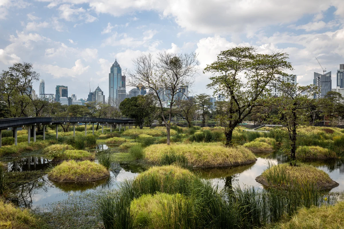
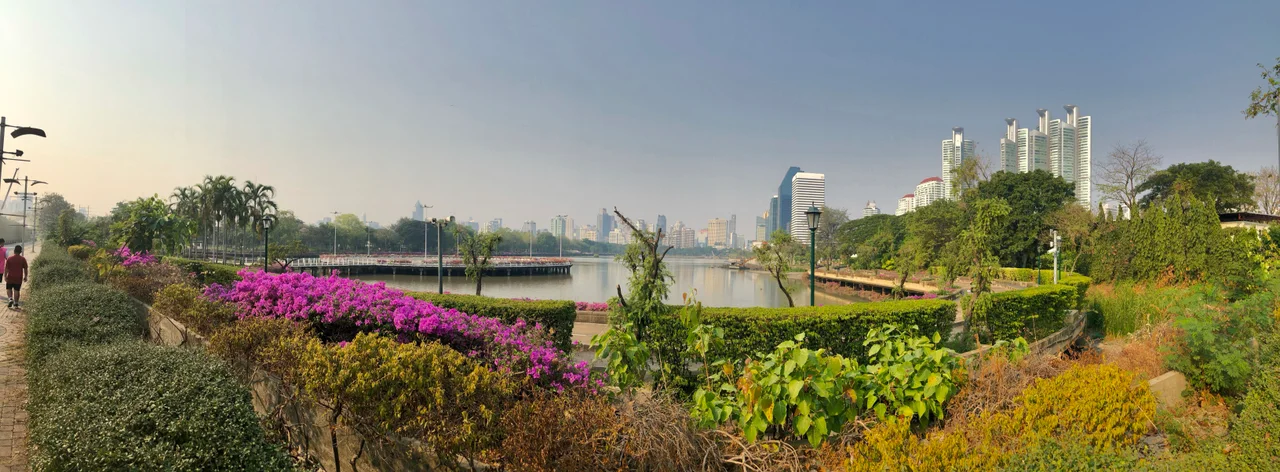
The main choice is between two landscapes. The eastern lake has broad views across open water and a straightforward shoreline route. West of it, the Forest Park has planted islands, winding ground-level paths and a raised skywalk. You can visit both through the connecting paths inside the park.
We recommend the forest section for a first visit because its raised paths reveal the shape of the wetlands from above; the lake adds a different view without requiring another journey. For mature shade and lawns, Lumphini Park is the better comparison. Benjakitti’s appeal is the contrast between the engineered wetland and the surrounding high-rises.
Tripadvisor reviewers praise the elevated walkways at sundown and the space for morning exercise. Google reviews collected on Top-Rated.Online also flag long walks to toilets and dark stretches after sunset. Choose your return gate before heading into the western paths, especially with children or limited walking stamina.
Entry, cycling and boats
Cycling has an earlier finish
The designated cycling route is 3.4 km long and opens from 06:00 to 17:30. Keep to the marked cycle lane. The wetland skywalk is a pedestrian route: park and lock your bicycle before exploring it on foot. An evening park opening does not extend the cycling session.
Independent bicycle hire
Bangkok Forest Cycling charges 350 THB for a city bike for two hours, with a helmet included. Its shop is at 233 Sukhumvit Soi 4, outside the park, and closes on Tuesdays. The operator holds a passport or ID card during the rental and returns it with the bicycle. Its booking form offers two-hour starts at 08:00, 10:30, 13:00 and 15:30.
This is an off-site bicycle rental, with collection and return at the shop; it is separate from park admission. Allow time to return the bicycle before the end of your slot. For a longer skywalk visit, return the bicycle first and continue on foot.
Choose a bicycle and collection time at Bangkok Forest Cycling. Advertisement · Bangkok Forest Cycling
Boating on the original lake
Pedal boats and kayaks are a municipal activity on the eastern lake. Sessions are free, last one hour and operate from 09:00 to 18:00. Go to the boating desk for registration and the next available session before planning the rest of your walk. This activity is separate from access to the wetland paths; a boat registration requirement does not mean you must book entry to the park.
Getting to the right entrance
The address is Ratchadaphisek Road, Khlong Toei, Bangkok 10110. On a map, distinguish the original lake from the Forest Park to its west. An arrival pin at the lake still leaves an internal walk to the wetland skywalk.
From the MRT
Use the Blue Line to Queen Sirikit National Convention Centre, Exit 3. Follow the park boundary north from the station towards the lakeside entrances. After entering, follow the connecting paths west towards the Forest Park and skywalk. The station exit is an arrival point at the park edge, rather than the start of the raised wetland route.
From BTS Asok or MRT Sukhumvit
From the Asok–Sukhumvit intersection, walk south along Ratchadaphisek Road on the park side to the northern lakeside entrance. Budget 15 minutes from the intersection to that entrance as a walking allowance, with more time for crossings. This approach suits a visit ending back in the Asok restaurant and shopping area.
From Lumphini via the Green Bridge
The Green Bridge, also called the Green Mile, connects Lumphini with Benjakitti’s northwest side. It is a separate route from the skywalk within the wetland. From Benjakitti, head towards the northwest corner near the former factory buildings and follow signs for Lumphini. Reddit discussions repeatedly describe difficulty finding this connection; heading back to the eastern lake takes you away from it.
Plan the Green Bridge crossing between 06:00 and 18:00, and read the access signs at its gate before setting off. Its gates operate separately from the parks. For a rail alternative, Lumphini and Queen Sirikit National Convention Centre stations are two stops apart on the Blue Line, with Khlong Toei between them.
A 90-minute walking plan

This is a suggested time budget starting at a lakeside entrance, with photo stops. It does not require completing every path.
- First 15 minutes: orient yourself at the lake, locate a toilet and choose your exit. Continue west into the forest section rather than circling the entire lake first.
- Next 45 minutes: follow a ramp onto the skywalk, pause above the wetland islands, then take a ground-level path back towards the lake. Look down as well as out at the skyline: the channels and planted mounds explain how the landscape holds water.
- Final 30 minutes: walk along the original lake for open-water views, then leave towards the MRT or Asok. If you plan to cross to Lumphini instead, turn northwest from the forest section and allow a separate walking budget for the bridge and second park.
For a shorter visit, choose either the lake or one out-and-back skywalk section. A ramp is also your route back down: turning towards a visible road does not necessarily lead to a park exit.
When to go and park rules
We suggest arriving at 16:30 for the walking plan, because it leaves daylight to find the wetland paths before the evening skyline photographs. Early morning suits exercise. Exposed skywalk sections have little shelter from sun or rain: bring drinking water, a hat and mosquito repellent, and use shoes with grip for wet paths. Buy supplies before entering the forest section.
For choosing travel dates, compare rainfall and winter air quality in our month-by-month guide to visiting Bangkok before making the park a daily fixture.
After dark, keep to the main paths and leave extra time to find your gate. During a thunderstorm, leave the raised walkways for a sheltered building rather than waiting on an exposed viewing platform. The Thailand Meteorological Department forecast and warnings helps with planning an outdoor visit.
- No smoking, alcohol or drone flying in the park.
- Stay on the paths, keep out of the wetland pools and leave plants undisturbed. Give wildlife space; keep children away from monitor lizards and do not feed them.
- Dogs use the designated Dog Park. Keep them out of the main forest walking route.
- Use the dedicated sports areas for their intended activities. Skateboarding belongs in the designated rink; keep pedestrian routes clear.
Wheelchairs, strollers and toilets
The raised wetland route includes ramps, and paved paths give wheelchair and stroller users an alternative to the lower nature trails. Keep small wheels on firm paving; loose surfaces and wet boardwalk joints need more care. A long ramp can also make the return longer than the straight-line distance on a map.
For a step-free visit, arrange your arrival around a street-level park gate and ask the attendant to identify the ramp route before entering the forest section. At the MRT, ask station staff for the lift route rather than treating Exit 3’s walking directions as a wheelchair itinerary. For assistance with the park entrance and an accessible toilet on your route, call 02 254 1263 before travelling.
There are nine public toilet buildings in the park, with free use. At the entrance map, locate a toilet before taking a wetland loop; if you need a wheelchair cubicle, have staff point out the suitable block and its approach. Keep a short route back to that facility rather than assuming each viewing platform has toilets nearby.
With a stroller, use the ramps and leave room for other walkers to pass at photo stops. Keep young children beside you on bridges and at water edges. A lake-only out-and-back makes it easier to turn around when a child tires than a route across the full forest section.
What to combine with your visit

Another park: take the Green Bridge route described above to Lumphini. Choose this as the main extension to your walk; adding it after the full 90-minute plan creates a considerably longer outing.
Food after the park: finish at the northern lakeside exit for Asok and Terminal 21. For the Queen Sirikit National Convention Centre, finish at the southern side of the lake instead. These are different departure points, so choose one before making a final circuit.
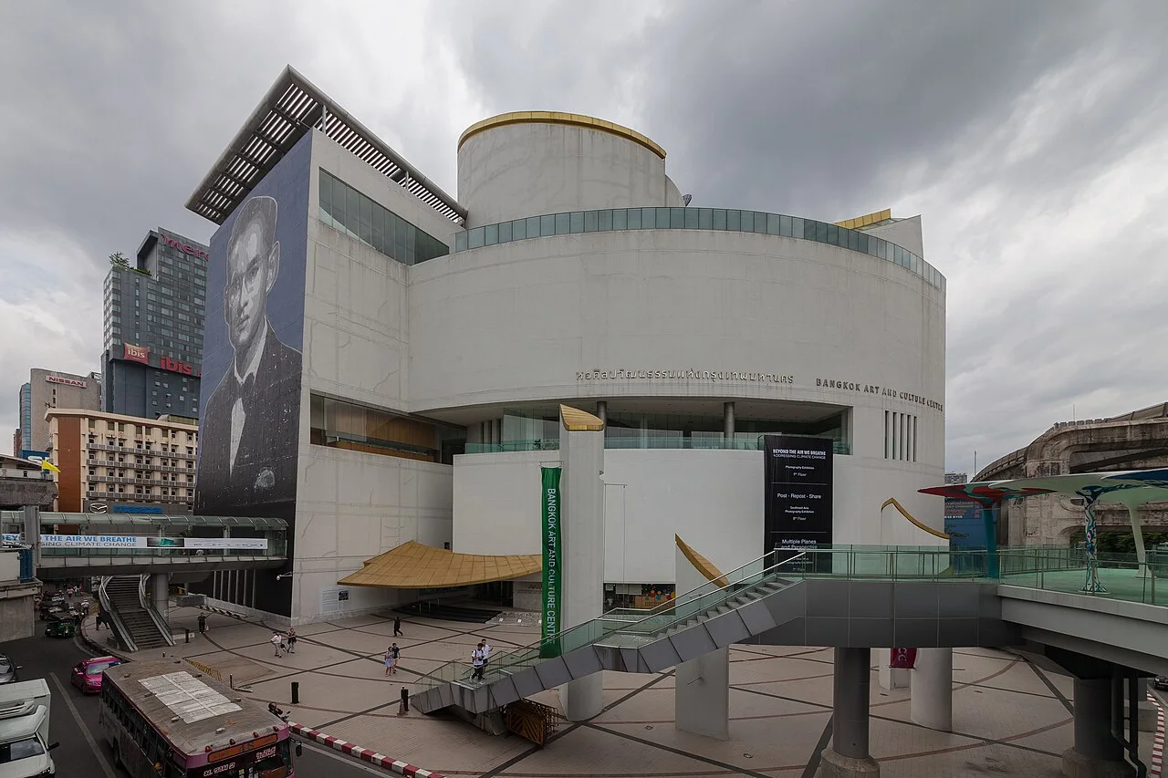
An indoor afternoon: visit Bangkok Art and Culture Centre before the park: BTS National Stadium connects to Asok via a change at Siam. For a paid observation deck above the skyline, compare Mahanakhon SkyWalk; Benjakitti’s pedestrian skywalk stays within the park and gives a much lower view across the wetlands.
How the wetland works
The wider Benjakitti park covers 450 rai, or 72 hectares. Its Forest Park expansion opened in 2022 on former Thailand Tobacco Monopoly land, with landscape design by Arsomsilp and Turenscape. Retained factory buildings and roads explain the straight corridors between the more irregular wetland areas.
The planted mounds keep tree roots above standing water while the surrounding channels hold rainfall. The wetland design has a storage capacity of 128,000 cubic metres and uses plants to treat water from Phai Sing To canal, with a design output of 1,600 cubic metres of clean water a day. These are landscape functions, not swimming or drinking-water facilities.
Demolition stone and concrete were reused in island foundations and filtration layers. From the walkways, look for the difference between open channels, densely planted islands and the preserved older trees. The changing water level and vegetation are part of the wetland’s working landscape.
Other questions
Is Benjakitti the same park as Benchasiri?
No. Benchasiri is beside BTS Phrom Phong and the Emporium shopping area. Benjakitti is beside the Queen Sirikit National Convention Centre. Check the map pin before travelling: the similar names can send you to a different station.
Can I organise a commercial shoot or a group event?
Organised events and commercial use require a separate venue application. Contact the park administration before fixing a date; ordinary visitor access does not reserve space for a group or production.
Author: Bangkok Guide editorial team · Updated
Keep exploring
Lumphini ParkBangkok Art and Culture CentreBangkok National Museum